It's a long list.

The path of totality will be about 9,200 miles long and 115 miles wide, on average, so it will cross through hundreds of towns and some major cities.
A new eclipse map—based on an updated figure for the radius of the sun—was published recently by John Irwin, a master in eclipse computations
Grazing Zone
None of this should alarm anyone who is planning to head deeper into the path of totality, but if you're home or school is the “grazing zone” then ... move on April 8! You will not regret experiencing even a few seconds of totality.
Here are 15 locations in the U.S. and Canada where the path of totality will likely be narrower than previously thought—by around 2,000 ft./600 meters—which means some people that were previously expecting a quick look at the sun's corona will now miss totality altogether.
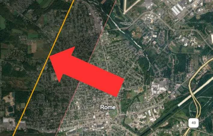
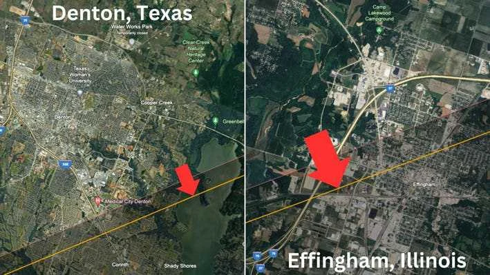
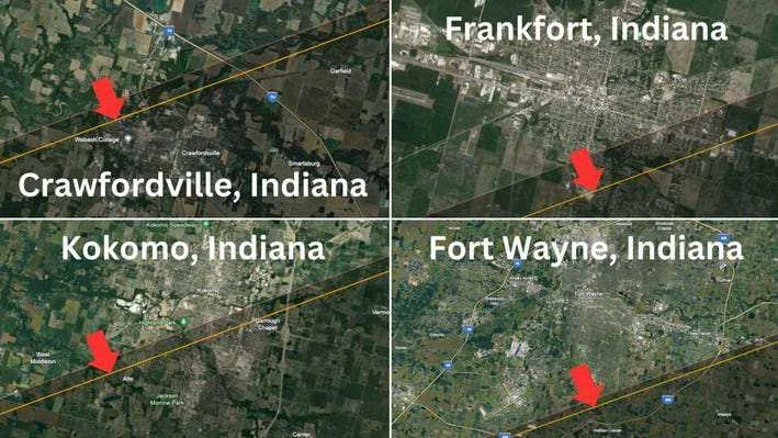
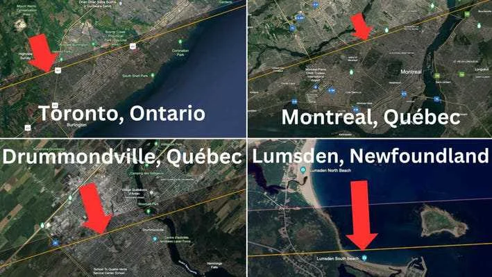
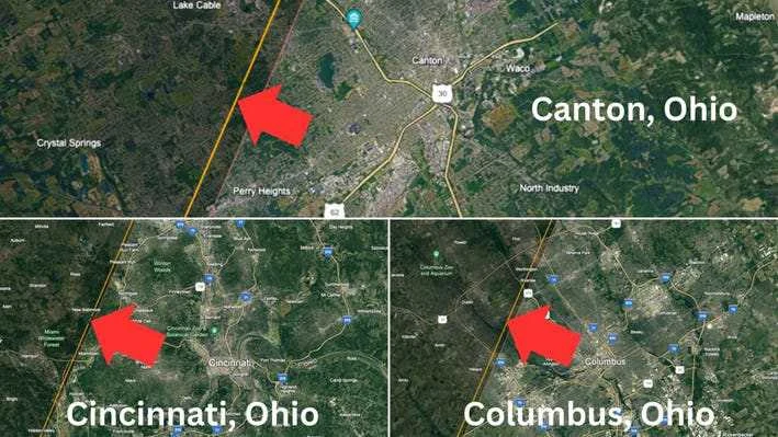
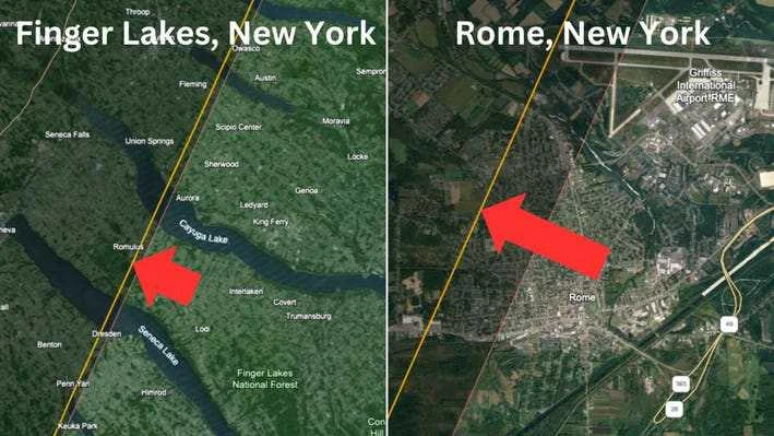
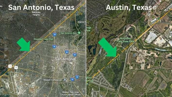
In all of these maps, the red line is the “classic” limit of the path of totality and the orange line is the “new” limit that uses the latest figure for the sun's radius. If there's a red arrow, it's means a loss. A green arrow is a gain.
Texas And Illinois: Northern Limit
The new map has alarming consequences for cities dissected by the edges of the path of totality. Denton, at the far north end of the Dallas-Fort Worth metroplex, gets a 99.95% partial solar eclipse. The advice was already to travel southeast to the southern half of Lewisville Lake for a short totality. Now it means going a little farther to make sure. It's a similar story in Effingham, Illinois.
Indiana: Northern Limit
Those on the southeast side of Kokomo, Indiana, will glimpse totality for a few seconds‚ but fewer people will see it than previously thought. It's the same with the far southeast corner of Frankfort, while Crawfordsville is just inside the path but has a super-short totality. The latter's northern suburbs are now outside the path.
Fort Wayne in Indiana is now farther from the path than it was.
Canada: Northern Limit
Montreal, Canada's Cité Jardin and its park—which contains the Olympic Village and the Olympic Stadium—are within the path of totality in standard eclipse maps. On Irwin's, it's just outside.
In Newfoundland, one of the last places thought to see totality in North America—Lumsden Beach—now will not.
Ohio: Southern Limit
On the southern edge, it's a more mixed picture, with the “new” limit beyond the “old” limit until the lines converge in Arkansas, then diverge.
In Ohio there are three “edge” cities whose CBDs must be avoided on April 8. That remains the case, it's just a little more extreme now
New York: Southern Limit
The Finger Lakes region of New York—many of its lakes already frustratingly split by the path of totality—now appear to be even less endowed with totality.
You may think this doesn't matter, but there are already many events planned for the edge of the path, and many schools situated near it. Luckily, St Michael's School in Penn Yann, New York is still just within the limit.
Instead of being split in two by the edge of the path, Rome, New York now appears to almost entirely outside of it.
Texas: Southern Limit
There are, however, tow distinct winners from the new map. Although San Antonio still requires great care on April 8 if totality is to be witnessed, the path of totality appears to have widened slightly in its favor.
It's a similar case for Austin, where the city's southeastern region is shunted slightly back into totality. Its airport still misses out, but where once its McKinney Falls State Park was outside the path of totality, it's suddenly now in it.

WHICH MEANS I MIGHT HAVE A BETTER CHANCE AT SEEING IT IN MAINE, SINCE BEFORE IT WAS SEVERELY NORTH OF ME.

(Please let me know if this is wrong flair/wrong title for post/not dramatic enough)




Jump in the discussion.
No email address required.
P. Diddler lmaol
Jump in the discussion.
No email address required.
It's a Freak-Off if you will
Jump in the discussion.
No email address required.
More options
Context
More options
Context